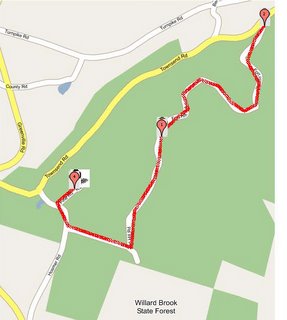
 According to its founder, the GMaps Pedometer is a "little hack" that uses Google's amazing mapping application to help record distances traveled for a walk, run or hike, without having to drag a GPS or pedometer around - a potential day-saver for a Day Tripper with a child in a backpack or stroller or someone with limited endurance. Other tools like Google Earth or MapQuest are easier for calculating driving distances - after all, this tool is called a pedometer - you must add individual points for all the twists and turns in your route to get an accurate distance. Click map for a larger image of this sample walk at Willard Brook State Forest.
 Tuesday, October 17, 2006
GMaps Pedometer Saves the Day
According to its founder, the GMaps Pedometer is a "little hack" that uses Google's amazing mapping application to help record distances traveled for a walk, run or hike, without having to drag a GPS or pedometer around - a potential day-saver for a Day Tripper with a child in a backpack or stroller or someone with limited endurance. Other tools like Google Earth or MapQuest are easier for calculating driving distances - after all, this tool is called a pedometer - you must add individual points for all the twists and turns in your route to get an accurate distance. Click map for a larger image of this sample walk at Willard Brook State Forest.